Minor Amendment to the Subregion 1 Master Plan and SMA
Minor Amendment to the Subregion 1 Master Plan and SMA
Project Contact Information
Elena Perry
TEL: 301-780-8156
EMAIL: elena.perry@ppd.mncppc.org
Justin Thornton
TEL: 301–780-8312
EMAIL: justin.thornton@ppd.mncppc.org
Hannah Menard
TEL: 3019523631
EMAIL: hannah.menard@ppd.mncppc.org
Kierre McCune
TEL: 301-952-3211
EMAIL: kierre.mccune@ppd.mncppc.org
View Open House Materials – January 21, 2026
Couldn’t make it out to the Open House? View the presentation, overview context boards, and map activities to get caught up.
The next step of the project will begin when the District Council formally initiates the Minor Plan Amendment project. After initiation, the draft plan and SMA amendments will be available for residents and stakeholders to review. Interested in learning more about the timeline for this and other Minor Plan Amendment projects? Check out the Engagement Opportunities Milestones.
Engagement Summary – Now Available
View the results from all the Subregion 1 Minor Plan Amendment project community engagement opportunities. This document includes the data collected and a summary of feedback and concerns raised by listening session and open house attendees, as well as survey respondents. View Engagement Summary here.

The Prince George’s County Planning Department is preparing an amendment to the 2010 Approved Master Plan and Sectional Map Amendment for Subregion 1. This minor plan amendment will create a forward-looking, market-viable framework to guide investment and economic development while enhancing the quality of life for residents and workers in the area.
Guided by the 2014 Plan Prince George’s 2035 General Plan (Plan 2035), the plan update will combine public participation, real estate market analysis, land use and zoning review, and regional best practices to shape updated planning recommendations. The recommendations will be grouped into plan elements such as land use, open space, economic development, housing, and transportation.
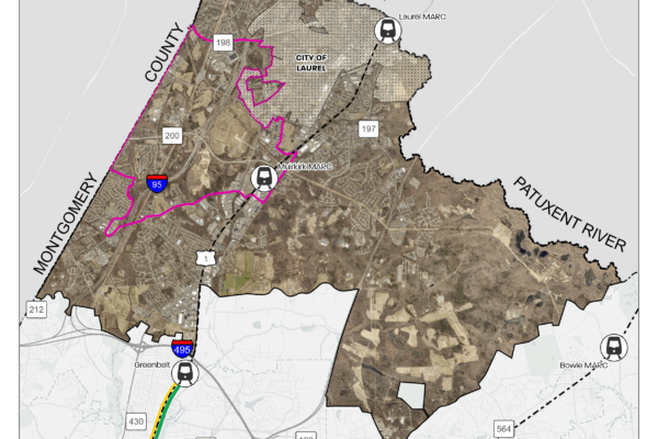
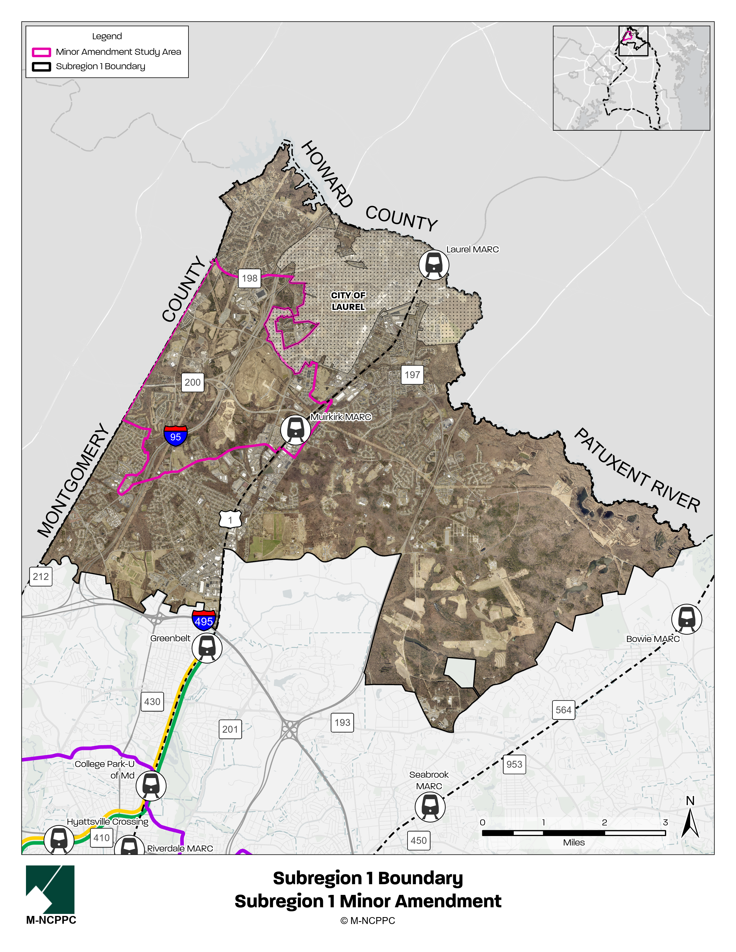
Covering approximately 44 square miles, Subregion 1 forms much of the County’s northern boundary bordering Howard County, Montgomery County, and Anne Arundel County and also abuts the City of Laurel. Subregion 1 acts as a northern gateway into Prince George’s County and is served by several major roads: I-95, Baltimore-Washington Parkway, U.S. Route 1, MD 200 (the Intercounty Connector), MD 198 (Sandy Spring Road), and MD 212 (Powder Mill Road). The unincorporated areas of Beltsville, Calverton, and Laurel, the Muirkirk MARC Station, Konterra Town Center, as well as the Henry A. Wallace Beltsville Agricultural Research Center (BARC), are features of the subregion.
The approved 2010 Subregion 1 Master Plan called for a “regenerated and reinvented ‘main street’ US 1 corridor, upgraded commercial and industrial areas, and a vibrant ‘downtown’ at the Konterra Town Center.” Since 2010, some significant developments have taken place, including the completion of MD 200 and the Brick Yard development near the Muirkirk MARC station. However, much of the growth envisioned in the master plan has not materialized. The goal of the minor plan amendment is to refocus the vision for Subregion 1 in light of current real estate market conditions, Plan 2035 land use goals, and other actual or emerging development opportunities and constraints.
If the minor plan amendment requires a zoning change for implementation, then the project will also include an amendment to the zoning map (“Sectional Map Amendment”).
The planning process features two public meetings in 2025, offering opportunities for residents, businesses, and stakeholders to share their preferences and priorities for the scale, character, and implementation of future development in Subregion 1.
Project Boundary Map
Timeline
| Milestone | Expected Timelines |
|---|---|
Listening Sessions | Fall 2025 |
| Initiation | Spring 2026 |
| Joint Public Hearing | Summer 2026 |
| Planning Board Adoption | Summer 2026 |
| Council Approval | Fall 2026 |
FAQs
How can I participate in the planning process?
This planning process features a unique community engagement approach designed to specifically capture resident and stakeholder feedback to inform the development of the minor plan amendment. Review this summary sheet, which outlines community engagement opportunities throughout the minor plan amendment process.
In conjunction with County Council District 1 Councilmember Tom Dernoga, a public town hall meeting was hosted in July 2025. (Review a recording of the meeting here and a summary of questions and answers here.) An additional listening session was held in Fall 2025, featuring a brief presentation and interactive engagement opportunities. Keep an eye on this project webpage and our social media channels to stay updated.
What is a Minor Plan Amendment?
A minor plan amendment is an update to an existing approved master plan or sector plan. Minor plan amendments are initiated by the County Council through a formal resolution. A plan amendment is classified as “minor” if it affects less than 50% of the area of the existing approved plan.
What is a Sectional Map Amendment?
A sectional map amendment (SMA) is a comprehensive rezoning amendment for properties within an entire geographic area, such as a subregion, planning area, or part of a planning area. The purpose of an SMA is to revise the zoning of property to conform to the recommendations of the applicable master plan or sector plan. If necessary, an SMA will be done concurrently with this minor plan amendment to recommend zoning changes for specific properties to achieve the master plan’s vision and goals.
What is zoning?
Zoning is the law that determines what can be built, where it can be built, and how it is built. Zoning works in two parts. The zoning ordinance is the written law and the zoning map shows where the different zoning regulations are applicable. There are several different types of zones, including Residential, Industrial, Commercial, Agricultural, Open Space, and Transit-Oriented zones. Each zone has a corresponding list of land uses that are allowed and not allowed inside them. For example, heavy industrial uses are not typically allowed in residential zones, but single-family homes are usually allowed. Different zones also have different permitted building heights, development densities, setback requirements, etc., all of which change the nature of the streetscape.
What are the implications of any zoning changes on a property in Subregion 1?
If the planning process recommends rezoning, that will happen at the end of the planning process through a legal update to the County Zoning Map. Even if a property is rezoned, nothing can physically happen to the property unless the owner initiates a change (e.g., sale or redevelopment). Keep in mind that master plans only produce recommendations for the future; no change can occur to a privately owned property unless initiated by the owner.
How will I know if my property is recommended for a different zone?
If your property is recommended for rezoning through this SMA, you will be notified through US mail, per 27-3407 Scheduling of Hearings and Public Notice of the Zoning Ordinance. Plan and zoning recommendations are evaluated through:
- A public comment period through the Joint Public Hearing (Planning Board and District Council) process
- Work sessions
Should the County Council recommend additional amendments to the master plan and/or SMA that were not raised in testimony at the Joint Public Hearing, they must hold an additional Joint Public Hearing on those amendments.
The Prince George’s County Planning Department welcomes and encourages public participation and feedback throughout the plan development and public review period. Note that the County Council has the power to approve the plan and authorize changes to the zoning map.
Does a change in zoning mean I am at risk of losing my property?
No. A master plan is aspirational and outlines goals and makes recommendations for the future of a planning area over a 25-year period. Master plans and zoning regulations do not remove ownership or impose development mandates on property owners. If a property owner wants to redevelop a property after the County approves a zoning change through the sectional map amendment, then the requirements of the property’s new zoning classification would apply.
What part of the County is in Subregion 1?
Subregion 1 is one of seven subregions in Prince George’s County, located in the northern portion of the County. The Subregion is approximately 44 square miles in size and constitutes approximately 11 percent of the County’s total land area. Subregion 1 forms much of the County’s northern boundary bordering Howard County, Montgomery County, and Anne Arundel County and acts as the northern gateway into Prince George’s County. The Subregion is served by major highways including I-95, Baltimore-Washington Parkway, U.S. Route 1, MD 200 (the Intercounty Connector), MD 198 (Sandy Spring Road), and MD 212 (Powder Mill Road). While no municipalities are contained in Subregion 1, the plan boundary contains the communities of Beltsville, North Beltsville, West Laurel, and South Laurel and abuts the City of Laurel. Portions of the Subregion fall into Plan 2035 Established Communities, Rural and Agricultural Areas, and two centers: Konterra Town Center and Muirkirk MARC Neighborhood Center.
What about the City of Laurel?
The City of Laurel has its own zoning and planning jurisdiction so the City makes land use decisions separate from the County Planning Department. Due to proximity, the City will be a stakeholder in the minor plan amendment process.
Agricultural Listening Session – December 18, 2025
In December 2025, the Subregion 1 Minor Plan Amendment team worked with the Subregion 5 and Subregion 6 Minor Plan Amendments project team to host a Listening Session specifically geared toward the agricultural community to inform updates for all three amendments. View the presentation and materials to learn more. View the Agricultural Listening Session here.
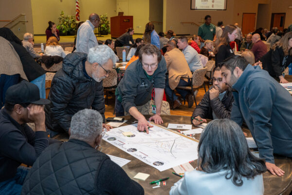
Listening Session – November 24, 2025
In November 2025, the Subregion 1 Minor Amendment team kicked off the main community engagement phase of the project by hosting a Listening Session to gather input from residents, business and property owners, and other stakeholders. Listening session activities included community prioritization buckets, a land-use Lego exercise, a love, more, less activity, six-word stories, and a word cloud.
Missed the Listening Session? View the presentation and context boards to get caught up!
Strengths, Weaknesses, Opportunities, and Threats (SWOT) Analysis
As part of the initial evaluation phase of the project, Stantec, consultant team leading the policy, land use, and public realm framework, took a closer look at the Study Area and developed an analysis of the Strengths, Weaknesses, Opportunities, and Threats within the Study Area. By examining the Study Area’s physical conditions, economic trends, environmental resources, and existing policies, the SWOT Analysis shows the Study Area has potential for intentional and targeted investment especially at Konterra Town Center and Muirkirk MARC station, improved multi-modal connectivity, and stronger community identity, but will require focused interventions to overcome market uncertainty and fragmented land use patterns. Review the SWOT Analysis.
Market Study
RCLCO, a sub-consultant, is a well-established firm that has worked with public agencies, non-profit organizations, universities, and private developers—both nationwide and right here in the County. Their team took a close look at the (re)development and improvement opportunities in the Subregion and Study Area.
To put together the Market Study Full Report, they drew on a wide range of factors: demographic and economic trends, real estate market conditions, community priorities, and the barriers and constraints that shape development. The result is analysis that outlines which types of uses make the most sense in key locations throughout the Study Area, along with ideas on when those opportunities are likely to be feasible. Review the Market Study Full Report.
Land Use and Zoning Analysis
Stantec, the consultant lead, also took a closer look at existing land-use patterns, land-use policy, zoning, and recent development activity within the Study Area and the greater Subregion. The Study Area is positioned to become a mixed-use and employment destination; however, some land use or zoning adjustments may be necessary to support the Study Area’s evolution. Review the Land Use and Zoning Analysis.