Publications
Image Carousel


Publications Information
Prince George's County 1996 Household Survey
Title:
Prince George's County 1996 Household Survey
Author:
The Maryland-National Capital Park and Planning Commission
Prince George's County Planning Department
Publication Date:
10/01/1996
Source of Copies:
The Maryland-National Capital Park and Planning Commission
14741 Governor Oden Bowie Drive
Upper Marlboro, MD 20772
Number of Pages:
2
Prince George’s County 1996 Household Survey.
Related Documents:
 1996 Household Survey
Preliminary Addison Road Metro Center Regulating Plan
Title:
Preliminary Addison Road Metro Center Regulating Plan
Author:
The Maryland-National Capital Park and Planning Commission
Publication Date:
05/01/2010
Source of Copies:
The Maryland-National Capital Park and Planning Commission
14741 Governor Oden Bowie Drive
Upper Marlboro, MD 20772
Number of Pages:
42
This document is the preliminary Addison Road Metro Center regulating plan. It implements the recommendations of the 2002 Prince George’s County Approved General Plan and updates the 2000 Approved Sector Plan and Sectional Map Amendment for the Addison Road Metro Town Center and Vicinity and the 2009 Adopted Subregion 4 Master Plan and Endorsed Sectional Map Amendment. Developed with input from the community, this document establishes functional overlays, allocates urban neighborhoods, sets forth building envelope standards, designates locations for public space and roadways, and specifies street types.
Potomac Airfield Report

Title:
Potomac Airfield Report
Author:
The Maryland-National Capital Park and Planning Commission
Prince George's County Planning Department
Publication Date:
06/01/1999
Source of Copies:
The Maryland-National Capital Park and Planning Commission
14741 Governor Oden Bowie Drive
Upper Marlboro, MD 20772
Number of Pages:
172
This report includes discussions of the background, history, aviation regulations, regional airspace, safety and accident probabilities, noise, various alternatives for ultimately solving this planning dilemma and recommendations.
Related Documents:
Plan Prince George's 2035 Approved General Plan Five-Year Evaluation (2019)

Title:
Plan Prince George's 2035 Approved General Plan Five-Year Evaluation (2019)
Author:
The Maryland-National Capital Park and Planning Commission
Prince George's County Planning Department
Source of Copies:
The Maryland-National Capital Park and Planning Commission
14741 Governor Oden Bowie Drive
Upper Marlboro, MD 20772
Number of Pages:
78
A comprehensive 20-year general plan, the 2014 Plan Prince George’s 2035 Approved General Plan (Plan 2035) articulates a shared vision for making Prince George’s County a competitive force in the regional economy, a leader in sustainable growth, a community of strong neighborhoods and municipalities, and a place where residents are healthy and engaged. Plan 2035 specifies indicators of success and growth management targets to measure progress toward the vision and goals described in Plan 2035. This 2019 Plan 2035 Five-Year Evaluation Report quantifies the indicators of success and identifies where progress has been made and where improvements are needed. The report measures the growth management policy regarding dwelling units and jobs targets by growth policy areas.
 Plan 2035
1994 Planning Area 68 Approved Master Plan and Sectional Map Amendment
Title:
1994 Planning Area 68 Approved Master Plan and Sectional Map Amendment
Author:
The Maryland-National Capital Park and Planning Commission
Prince George's County Planning Department
Source of Copies:
The Maryland-National Capital Park and Planning Commission
14741 Governor Oden Bowie Drive
Upper Marlboro, MD 20772
Number of Pages:
170
This document contains maps and supporting text of the Approved Planning Area 68 Master Plan and the Adopted Sectional Map Amendment (SMA). The Plan supersedes the 1974 Planning Area 68 Master Plan. The zoning proposals contained herein supersede the 1982 SMA. This Plan is also an amendment to The General Plan for the Maryland-Washington Regional District within Prince George’s County, Maryland, approved by the County Council in 1982; the 1983 Master Plan for Public School Sites; the 1992 Historic Sites and Districts Plan; the 1975 Countywide Trails Plan (including the 1985 Equestrian Addendum); the 1982 Master Plan of Transportation; and the 1990 Public Safety Master Plan. Developed by the Commission with the assistance of the Planning Area 68 Citizens Advisory Committee and other interested community participants, the Plan includes a vision for the future of the community developed by the committee. It also includes an historical overview and a community profile of the development of the communities of the Planning Area. Planning themes which were identified for the Planning Area include community reinvestment, transportation and natural resources. The central theme established for the Plan is to create a supportive and committed partnership among representatives from County and local government, residents and businesses to develop and implement strategies that improve the community. Goals, objectives and recommendations to guide public policy and investment in the Planning Area are presented for the eight major elements of the Plan: residential neighborhoods, commercial areas, industrial employment centers, the transportation and circulation network, the trails system, parks and recreation, natural resources and public facilities. Since a major focus of the Plan is on revitalization, specific recommendations addressing community revitalization needs are presented, including two new zones for the US 1 corridor. Detailed revitalization plans are also presented for the Hyattsville, Mount Rainier and Riverdale Town Centers and for the Brentwood and North Brentwood Industrial Employment District. Specific action steps are identified to implement major plan recommendations. The SMA includes other zoning changes which are also designed to implement the Plan’s recommendations.
Related Documents:
Plan for Capacity Building Using 3D Modeling & Planning Decision Support Systems
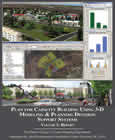
Title:
Plan for Capacity Building Using 3D Modeling & Planning Decision Support Systems
Author:
The Maryland-National Capital Park and Planning Commission
Prince George's County Planning Department
Source of Copies:
The Maryland-National Capital Park and Planning Commission
14741 Governor Oden Bowie Drive
Upper Marlboro, MD 20772
Number of Pages:
150
The Maryland-National Capital Park and Planning Commission (M-NCPPC), recognizing the value of 3D modeling and Planning Decision Support Systems (PDSS) as well as the challenges involved with implementing these tools, issued an RFP for a “Plan for Capacity Building Using 3D Modeling Applications & Planning Decision Support Systems” for the Prince George’s County Planning Department. The RFP stipulated that the Plan included an in-depth needs assessment of the Department, an evaluation of available tools, and a survey documenting the use of 3D modeling and PDSS tools by other planning departments across the nation. As a resource for other planning agencies, the first half of the report is available for download using the links below. The posted chapters summarize the findings and recommendations of the report (Chapter 1), give an overview of the methodology used (Chapter 2), document the results and findings of the national online survey and agency interviews (Chapter 3), and describe and evaluate many of the leading tools in the industry (as of early 2010, Chapter 4).
Related Documents:
Piscataway Village Rural Conservation Study Part II: Village Design Guidelines

Title:
Piscataway Village Rural Conservation Study Part II: Village Design Guidelines
Author:
The Maryland-National Capital Park and Planning Commission
Prince George's County Planning Department
Source of Copies:
The Maryland-National Capital Park and Planning Commission
14741 Governor Oden Bowie Drive
Upper Marlboro, MD 20772
Number of Pages:
88
This report is the second part of a multiyear study of the rural village of Piscataway. The first part, published in 1991, documented the history of the village, defined its unique character, and proposed design concepts and methods to protect its rural and historic qualities. The purpose of this report is to provide detailed design guidelines to assist the residents of the community in protecting the character of the village. The study was begun in late 1991, and completed in February 1995. This report, as well as the earlier study, was requested by the Historic Preservation Group of the Piscataway Citizens’ Association. The historic Village of Piscataway is located in the southwest portion of Prince George’s County, on Floral Park Road between Livingston Road and Piscataway Road. Of the remaining buildings, the earliest date from the mid-eighteenth century and the most recent from the first half of the twentieth century, all of which retain their significant architectural detail. This report is divided into four primary sections: Background, Historic Preservation in Piscataway, Village Design Guidelines and Conclusions. The report includes a summary of the historical development of Piscataway, an analysis of the village’s existing character, and an overview of existing development regulations and recent development proposals. It also includes an examination of existing preservation regulations affecting the village, as well as a building-by-building review of the village’s historic resources. Design Guidelines are provided for general maintenance, rehabilitation, additions, site improvements, new construction and streetscape improvements. The report concludes with a list of additional measures for protecting the character of Piscataway. The report is supplemented with photographs, maps and illustrations.
Related Documents:
Piscataway Village Rural Conservation Study
Title:
Piscataway Village Rural Conservation Study
Author:
The Maryland-National Capital Park and Planning Commission
Prince George's County Planning Department
Source of Copies:
The Maryland-National Capital Park and Planning Commission
14741 Governor Oden Bowie Drive
Upper Marlboro, MD 20772
Number of Pages:
51
This report details the findings of a study on the 18th century village of Piscataway, requested by the Piscataway Citizens Association. The goals of the project were 1) to document the history of the village, using land records research and early maps to define the extent and size of the village since its establishment; 2) to define the character of the village; 3) to propose design concepts to guide new construction in order to retain village character; and 4) to propose methods to help retain a buffer zone around the village and the open space within the village. This report begins with a history of Piscataway, including its significance as a port and government tobacco inspection location during the 18th century, and a documentation of the location of its schools and post office. Next, the existing conditions within the village are described and the historic, rural character of the village defined. The architecture of the buildings within the village is discussed and analyzed. Design concepts for sympathetic new construction within the village are proposed and strategies for protection of the open space within and around the village are offered. The report is supplemented by photographs and maps.
Related Documents:
Piscataway Village Community Vision Process

Title:
Piscataway Village Community Vision Process
Author:
The Maryland-National Capital Park and Planning Commission
Prince George's County Planning Department
Source of Copies:
The Maryland-National Capital Park and Planning Commission
1616 McCormick Drive
Largo, MD 20774
This document is the third part of a multiyear study of the rural village of Piscataway, located in south Prince George’s County on Floral Park Road between Livingston Road and Piscataway Road. The report, published in July 1991, documented the history of the village, defined its unique character, proposed design concepts and methods to protect its rural and historic qualities. The second report, dated February 1995, provided detailed architectural design guidelines to assist the residents of the community in preserving the character of the village. The third part of the study continued the previous efforts of community visioning workshops with local residents. Through a collaborative approach with participants, the workshops used drawings, photographs, images, and charts to develop a consensus about the common visual and physical qualities. This report documents the community visioning process undertaken from February to June 1995. This report is divided into seven sections, with each section documenting one of the community vi workshops. A process chart illustrating the chronology of the seven workshops is included in this doc The structure of the workshops was organized around the following broad categories: History and Inv Analysis, Alternatives, Implementation and Next Steps. Each section begins with the meeting minutes j workshop, followed by charts, sketches, maps and diagrams relating to the topics discussed by the we participants. Several workshops focused on identifying and analyzing the physical design features within the village. Topics included village integrity/character, infill development, open space, a “community” center, gateways, landscape setting, streetscape elements, and circulation patterns. Other workshop disc concentrated on methods for protection of historic resources, implementation strategies and funding (Products of the visioning workshops included design guidelines, landscape master plan recommendation), and an implementation strategy chart. The letter requesting this work effort from the Piscataway Historic Preservation Group is included document. The project was carried out under the Planning Department’s FY 1995 Community Preset and Design Workshops Work Program.
Related Documents:
Oral History Interviews for the African-American Heritage Survey 2008

Title:
Oral History Interviews for the African-American Heritage Survey 2008
Author:
The Maryland-National Capital Park and Planning Commission
Source of Copies:
The Maryland-National Capital Park and Planning Commission
14741 Governor Oden Bowie Drive
Upper Marlboro, MD 20772
Number of Pages:
156
During the 1996 celebration of the county’s Tricentennial, the Maryland-National Capital Park and Planning Commission published the African-American Heritage Survey. The publication documented 107 historic properties and 14 historic communities of significance to Prince George’s County African-American history and heritage including residences, schools and lodge halls, churches and cemeteries, and urban and rural communities.The interviews are filled with rich detail about day-to-day life in Prince George’s County and will assist in the efforts of many groups to document and perpetuate the county’s African-American heritage for future generations.
Related Documents: