Publications


Farm Properties
Title:
Farm Properties
Author:
The Maryland-National Capital Park and Planning Commission
Prince George's County Planning Department
Source of Copies:
The Maryland-National Capital Park and Planning Commission
14741 Governor Oden Bowie Drive
Upper Marlboro, MD 20772
This report is printed by special request. Price will vary based on original report and additional pages. Cover page images and report description are not available at this time. Publications are available for purchase at the M-NCPPC Planning Information Services, located on the Lower Level Floor (L) of the County Administration Building, Upper Marlboro, MD (now accepting payment Mastercard and Visa credit cards). If you have any question, please feel free to contact the Planning Information Counter at (301) 952-3195.
Document not available for download.
The Village of Brandywine Sidewalk and Streetscape Improvements Study: 30% Design and Engineering Report
Title:
The Village of Brandywine Sidewalk and Streetscape Improvements Study: 30% Design and Engineering Report
Author:
The Maryland-National Capital Park and Planning Commission
Prince George's County Planning Department
Publication Date:
10/01/2021
Source of Copies:
The Maryland-National Capital Park and Planning Commission
14741 Governor Oden Bowie Drive
Upper Marlboro, MD 20772
Number of Pages:
108
This report describes the goals, considerations, and recommendations for the 30% preliminary design and engineering plans and construction cost estimate developed for the Brandywine Sidewalk & Streetscape Improvements Project. This project was funded through the Planning Assistance to Municipalities and Communities (PAMC) Program administered by the Prince George’s County Planning Department.
Related Documents:
 Brandywine_Design
The Southern Avenue Metro Station Area Pedestrian Accessibility Study
Title:
The Southern Avenue Metro Station Area Pedestrian Accessibility Study
Author:
The Maryland-National Capital Park and Planning Commission
Prince George's County Planning Department
Publication Date:
12/01/2023
Source of Copies:
The Maryland-National Capital Park and Planning Commission
1616 McCormick Drive
Largo, MD 20774
Number of Pages:
82
This report is an evaluation of the pedestrian, bicycle, and safety conditions around the Southern Avenue and Naylor Road Metro Station areas. The report was developed through a process of identifying challenges and opportunities associated with the station areas. The findings and recommendations presented in this report do not necessarily represent the official policy positions of any members of the Maryland-National Capital Park and Planning Commission (M-NCPPC) and should not be read as such.
Related Documents:
The Prince George's County Public Facilities Needs Assessment Study
Title:
The Prince George's County Public Facilities Needs Assessment Study
Author:
The Maryland-National Capital Park and Planning Commission
Prince George's County Planning Department
Publication Date:
05/01/2013
Source of Copies:
The Maryland-National Capital Park and Planning Commission
14741 Governor Oden Bowie Drive
Upper Marlboro, MD 20772
Number of Pages:
58
As background information for the General Plan Update, Plan Prince George’s 2035, this Public Facilities Needs Assessment (PFNA) will inventory existing public facilities within Prince George’s County. It will include public libraries, fire and emergency medical services stations, public schools, county police district stations, a sheriff facility, park and recreation facilities, and park police facilities.
Related Documents:
The Houses of Fairmount Heights, Maryland: A Pattern Book
Title:
The Houses of Fairmount Heights, Maryland: A Pattern Book
Author:
The Maryland-National Capital Park and Planning Commission
Prince George's County Planning Department
Publication Date:
03/01/2022
Source of Copies:
The Maryland-National Capital Park and Planning Commission
14741 Governor Oden Bowie Drive
Upper Marlboro, MD 20772
Number of Pages:
142
This pattern book is part of an FY 2019 and FY 2020 M-NCPPC Planning Assistance to Municipalities and Communities (PAMC) Program project requested by the Town of Fairmount Heights to update the 1993 Fairmount Heights, Maryland Residential Façade and Improvement Guidelines. It identifies over 500 single-family dwellings, classifies and maps them by style and dates of construction, explains the origins and characteristics of each style, provides photographs, and in certain instances provides new research on the early builders and homeowners. It identifies vacant properties in the town and provides five new dwelling designs that are compatible with the existing dwellings and streetscape. It is a companion to the 1993 Fairmount Heights, Maryland Residential Façade and Improvement Guidelines publication which is being reprinted.
Related Documents:
2000 The Heights and Vicinity Approved Master Plan and Sectional Map Amendment

Title:
2000 The Heights and Vicinity Approved Master Plan and Sectional Map Amendment
Author:
The Maryland-National Capital Park and Planning Commission
Prince George's County Planning Department
Publication Date:
11/01/2000
Source of Copies:
The Maryland-National Capital Park and Planning Commission
14741 Governor Oden Bowie Drive
Upper Marlboro, MD 20772
Number of Pages:
248
This document contains maps and supporting text of the Approved Master Plan and Sectional Map Amendment (SMA) for the Heights and Vicinity. The plan supersedes the 1981 Adopted and Approved Master Plan for Subregion VII (for Planning Area 76A only). The zoning changes contained herein supersede the 1984 Sectional Map Amendment for Subregion VII (for Planning Area 76A only). The plan is also an amendment to the General Plan for the Maryland-Washington Regional District within Prince George’s County, Maryland, approved by the County Council in 1982, and other plans identified in the section entitled “Planning Context” Developed by the Commission with the assistance of the Heights and Vicinity Planning Advisory Group, this plan analyzes population, employment, land use and zoning characteristics. The plan sets forth goals, concepts, recommendations and guidelines for 11 major planning elements. This document also makes recommendations to implement the master plan during the ongoing planning and regulatory process. The SMA section includes zoning changes which are designed to implement the plan’s land use recommendations.
Related Documents:
The Future of Agriculture in Prince George's County, Maryland
Title:
The Future of Agriculture in Prince George's County, Maryland
Author:
The Maryland-National Capital Park and Planning Commission
Prince George's County Planning Department
Publication Date:
05/01/2005
Source of Copies:
The Maryland-National Capital Park and Planning Commission
14741 Governor Oden Bowie Drive
Upper Marlboro, MD 20772
Number of Pages:
52
This document describes the transformation of agriculture and its potential in Prince George’s County. After a brief overview and myths and facts about the county’s agriculture, it portrays the characteristics of farms and farmland. The report provides information on farmland protection and profitable farming and lists opportunities for diversifying and marketing strategies for farmers. Following a discussion on challenges and benefits of farming at the urban edge, the report concludes with recommendations to transform agriculture into a viable industry. in Prince George’s County. After a brief overview and myths and facts about the county’s agriculture, it portrays the characteristics of farms and farmland. The report provides information on farmland protection and profitable farming and lists opportunities for diversifying and marketing strategies for farmers. Following a discussion on challenges and benefits of farming at the urban edge, the report concludes with recommendations to transform agriculture into a viable industry.
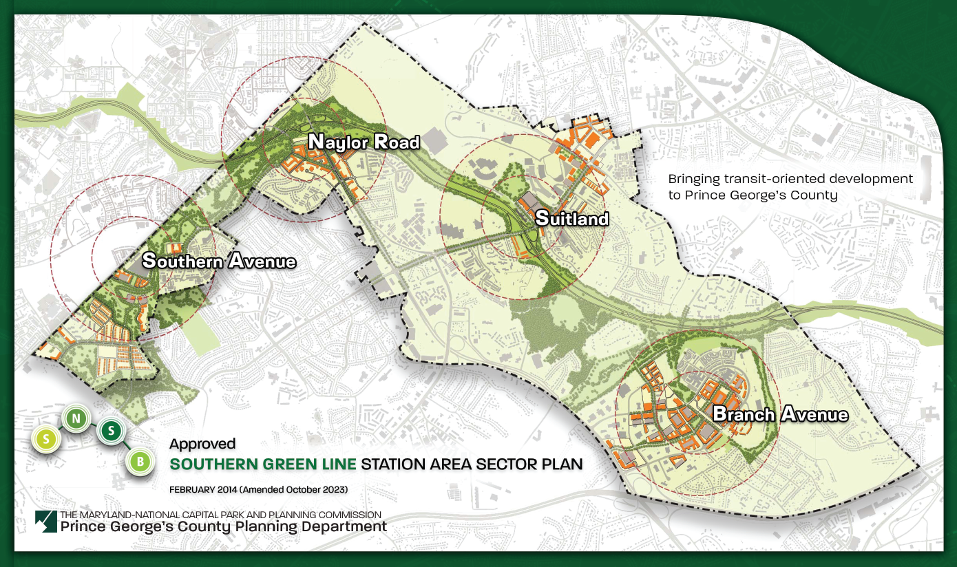
2014 Approved Southern Green Line Station Area Sector Plan with 2023 Minor Amendments (Amended October 2023)
Title:
2014 Approved Southern Green Line Station Area Sector Plan with 2023 Minor Amendments (Amended October 2023)
Author:
The Maryland-National Capital Park and Planning Commission
Publication Date:
02/01/2014
Source of Copies:
The Maryland-National Capital Park and Planning Commission
1616 McCormick Drive,
Largo, MD 20772
Number of Pages:
225
The Approved Southern Green Line Station Area Sector Plan seeks to bring transit-oriented development to the four Metrorail station areas along the Southern Green Line: Branch Avenue, Suitland, Naylor Road, and Southern Avenue to maximize the potential for economic and community development, and identifies opportunities for infill and redevelopment, sets a vision for each station area, and makes recommendations for future land use, creation of new Transit-Oriented Development zoning districts, regional and local roadway projects, and pedestrian and bicycle facilities and outlines implementation strategies, including specific recommendations for rezoning through the approved SMA where existing zoning districts can be applied to facilitate plan implementation.
Related Documents:
2014 Approved Landover Metro Area and MD 202 Corridor Sector Plan and Sectional Map Amendment

Title:
2014 Approved Landover Metro Area and MD 202 Corridor Sector Plan and Sectional Map Amendment
Author:
The Maryland-National Capital Park and Planning Commission
Prince George's County Planning Department
Publication Date:
06/01/2014
Source of Copies:
The Maryland-National Capital Park and Planning Commission
14741 Governor Oden Bowie Drive
Upper Marlboro, MD 20772
Number of Pages:
102
The Prince George’s County Planning Board of The Maryland-National Capital Park and Planning Commission is pleased to make available the Landover Metro Area and MD 202 Corridor Approved Sector Plan and Sectional Map Amendment. This sector plan provides a new vision for the Landover Metro area and the MD 202 Corridor between Barlowe Road and the Baltimore-Washington Parkway that will transform Landover from an auto-oriented community to one that is a vibrant pedestrian- and bicyclist-friendly community where people wish to live, work, and play.
Related Documents:
The Approved Prince George's Plaza Transit District Development Plan and Transit District Overlay Zoning Map Amendment
Title:
The Approved Prince George's Plaza Transit District Development Plan and Transit District Overlay Zoning Map Amendment
Author:
The Maryland-National Capital Park and Planning Commission
Prince George's County Planning Department
Publication Date:
07/01/2016
Source of Copies:
The Maryland-National Capital Park and Planning Commission
14741 Governor Oden Bowie Drive
Upper Marlboro, MD 20772
Number of Pages:
383
This document is the Transit District Development Plan (TDDP) and Transit District Overlay Zoning Map Amendment (TDOZMA) for the Prince George’s Plaza Regional Transit District. The plan contains a comprehensive vision to guide future development within the area along with implementation strategies to help realize the development vision. The Plan replaces the 1998 Prince George’s Plaza Approved Transit District Development Plan for the Transit District Overlay Zone. It also amends portions of the Plan Prince George’s 2035 Approved General Plan, the 1983 Adopted and Approved Functional Master Plan for Public School Sites, the 1994 Planning Area 68 Approved Master Plan and Sectional Map Amendment, the 2009 Countywide Master Plan of Transportation, and Formula 2040: Functional Master Plan for Parks, Recreation and Open Space (2014) for the portion of Planning Area 68 within the Prince George’s Plaza Regional Transit District and the Prince George’s County Zoning Map for tat portion of Planning Area 68 within the Regional Transit District.