Find a Plan or Project
Search Projects and Active Plans
Minor Amendment to the Subregion 1 Master Plan and SMA
NewsOverviewMap & TimelineFAQs/Resources News View Open House Materials – January 21, 2026 Couldn’t make it out to the Open House? View the presentation, overview…
Minor Amendment to the Subregion 6 Master Plan and SMA
NewsOverviewMap & TimelineResources News Land Use & Zoning Analysis Stantec, the consultant lead, reviewed existing land-use patterns and policy, zoning,…
Cultural Arts Study
On April 16, 2020, the Maryland-National Capital Park and Planning Commission released the Prince George’s Cultural Arts Study solicitation for consulting services to assist in developing strategies and recommendations for integrating cultural arts into the County’s economic development and land-use planning strategies. The closing date for this solicitation was May 14, 2020.
Study
Learn MoreSuitland Cultural Arts Implementation Strategy
The Suitland Cultural Arts Implementation Strategy will build upon the Prince George’s County Cultural Arts Study. Its primary objective is to identify ideal locations for creative placemaking. The Strategy will also craft conceptual designs tailored to each location’s unique characteristics and community needs.
Study
Learn More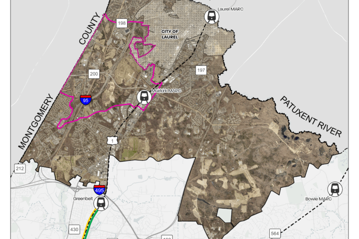
Minor Amendment to the Subregion 1 Master Plan and SMA
The Prince George’s County Planning Department is preparing an amendment to the 2010 Approved Master Plan and Sectional Map Amendment for Subregion 1. This minor plan amendment will create a forward-looking, market-viable framework to guide investment and economic development while enhancing the quality of life for residents and workers in the area.
Minor Amendment
Learn More
Minor Amendment to the Subregion 6 Master Plan and SMA
The Prince George’s County Planning Department is preparing an amendment to the approved 2013 Subregion 6 Master Plan and Sectional Map Amendment. This minor plan amendment is intended to establish a forward-looking, market-viable framework that enables investment and economic development while enhancing quality of life for residents and workers in the area.
Sectional Map Amendment
Learn MoreCompleted Plans
General Plan
Active Master Plans and Sector Plans (by Region/District)
Northern
DISTRICT 1
DISTRICT 2
DISTRICT 3
Central
DISTRICT 4
DISTRICT 5
DISTRICT 6
Southern
DISTRICT 7
| Project | Completed |
|---|---|
| Capitol Heights Vacant Lot Strategy | 2025 |
| The Southern Avenue Metro Station Area Pedestrian Accessibility Study | 2023 |
| Suitland Metro Station and Silver Hill TNI Pedestrian Accessibility Study | 2020 |
| Seat Pleasant Streetscape Improvements | 2019 |
| MD 704 (Martin Luther King Jr. Hwy) Streetscape Enhancement 30% Design and Engineering Report | 2019 |
| City of Seat Pleasant Youth Survey | 2018 |
| Approved Southern Green Line Station Area Sector Plan | 2014 |
| Approved Central Branch Avenue Corridor Revitalization Sector Plan | 2013 |
| Approved Subregion 4 Master Plan | 2010 |
| St. Barnabas-Beech Road Industrial Study and Action Plan | 2010 |
| Approved Marlboro Pike Sector Plan | 2009 |
| Approved Capitol Heights Transit District Development Plan | 2008 |
| Approved Branch Avenue Corridor Sector Plan | 2008 |
| Suitland Mixed-Use Town Center Development Plan | 2006 |
| Approved Master Plan for The Heights and Vicinity (Planning Area 76A) | 2000 |
DISTRICT 8
| Project | Completed |
|---|---|
| Henson Creek Village Area Study | 2021 |
| Approved Eastover/Forest Heights/Glassmanor Sector Plan (Portions of Planning Area 76A) | 2014 |
| Approved Southern Green Line Station Area Sector Plan | 2014 |
| Approved Central Branch Avenue Corridor Revitalization Sector Plan | 2013 |
| Approved Master Plan for the Henson Creek-South Potomac Planning Area | 2006 |
| Approved Master Plan for The Heights and Vicinity (Planning Area 76A) | 2000 |
DISTRICT 9
| Project | Completed |
|---|---|
| Accokeek Heritage Tourism Study | 2023 |
| Aquasco-Woodville Cultural Resources Inventory | 2022 |
| Approved Bowie-Mitchellville and Vicinity Master Plan and Sectional Map Amendment | 2022 |
| The Village of Brandywine Sidewalk and Streetscape Improvements Study: 30% Desiign and Engineering Report | 2021 |
| Town of Upper Marlboro Design Guidelines | 2014 |
| Conserving Significant Cultural Landscapes: Protecting the Piscataway and Accokeek Historic Communities and the Mount Vernon Viewshed | 2013 |
| Approved Central Branch Avenue Corridor Revitalization Sector Plan | 2013 |
| Approved Subregion 6 Master Plan | 2013 |
| Approved Subregion 5 Master Plan | 2013 |
| Brandywine Revitalization and Preservation Study | 2011 |
| Upper Marlboro Town Action Plan | 2009 |
| Approved Master Plan for the Henson Creek-South Potomac Planning Area | 2006 |
| Piscataway Village Rural Conservation Study | 1991 |
Completed Countywide Functional Master Plans
- Resource Conservation Plan (2017) – (an update of the 2006 Priority Preservation Area Functional Master Plan)
- Approved Historic Sites and Districts Plan (2010)
- Water Resources Master Plan (2010)
- Approved Countywide Master Plan of Transportation (MPOT) (2009)
- Public Safety Facilities Master Plan (2008)
- Approved Green Infrastructure Master Plan (2005)
Standalone Comprehensive Zonings
Publications and Online Documents
We offer downloads of online documents and printed copies upon request (certain fees may apply). To request documents not found in our publications directory, please use the Maryland Public Information Act Request (MPIA) link above.
Contact Us
Management Services Division
PHONE: 301-780-2026